Rinjani Information
Indonesia has highest of number of volcanoes than any other country in the world, crossed by the ring of fire which crosses through Indonesia and on through the pacific ocean. Indonesia has over 400 volcanoes, with over 100 of these active. Mt Rinjani Lombok Island one of the most impressive volcanoes in Indonesia. It is surrounded by a spectacular cobalt blue lake the Segara Anak Lake and the Gunung Baru Jari is the name of the new volcano which emerged in the center the Segara Anak Lake.
At 33,726 m above sea level, Mt Rinjani is the second highest volcano in Indoneia after Mt Kerinci in the Sumatra and arguably the most important tourist attraction on Lombok. Around 40,000 people from 60 different countries visited the Rinjani mount volcano from the April to December trekking season Each year.
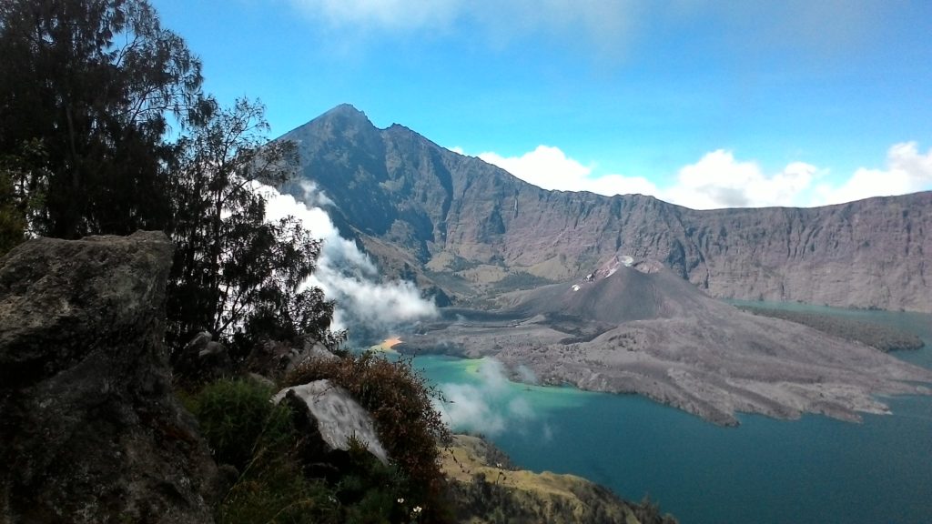
Rinjani is famous not just for its impressive height but also its incredible beauty. The volcano is surrounded by tropical rainforest on the lower slopes with savannahs plains on the upper slopes and topped with a jagged peak of rocks and lava sand on the summit. The huge caldera within the volcano is around 4 km wide and is almost filled by a beautiful lake, Danau Segara Anak. The lake is around 230 m deep and contains plentiful fish, as well as being home to birds and other wildlife.
Beware of bad weather and risks of exposure to the wet and cold (hypothermia). If caught in an electrical storm, take shelter and avoid prominent ridges. Beware of snakes, and stinging insects and plants. Leeches can be a nuisance in the wet season.
Geography.
Erupted History
The June 1994 eruption. At 02:00 pm, on June 3rd, 1994, Baru Jari come began erupting by sending an ash plume 500 m high. On June 8th, press report described emission of “smoldering lava” and “thick smoke”, as well as ash fall in nearby villages from an ash cloud rising 1,500 m above the summit. Between 3rd and 10th of June, up to 172 explosions could be heard each day from the Sembalun Lawang volcano observatory (15 km NE). During this period. seismic data indicated a dramatic increase in the number of explosions per day, from 68 to 18,720. Eruptions were continuous at least through 19th of June, with maximum ash plume heights of 2,000 m on 9th to 11th. The ash plume generally drifted SE, depositing up to 30 mm of ash on the island. Stromboli an eruptions ejected pyroclastic material > 2m in size as high as 600 m above the vent; this material fell in a restricted proximal area around the cone and in the lake. Lava flows began on 8th of June and partially covered previous lava flows from Rombongan (in 1944) and Baru Jari (in 1966).
A series of aircraft warnings based on pilot reports and weather satellite images indicated much larger plumes than suggested by the ground observations. First an eruption at about 12:00 on June 7th produced a long plume that caused a large number of aviation warnings. The plume, located on satellite imagery, extended 120 km S of Rinjani and was beginning to disperse by 15:30. A pilot report at 16:45 indicated a “smoke” plume to 13,500 m altitude moving ESE, but by 23:45 the plume was in distinguish- able on satellite imagery. The imagery showed a plume around 06:33 on the 8th of June, which extended at least 83 km SE of the volcano. Aircraft were advised to avoid this area to an altitude of 10,500 m. above sea level.